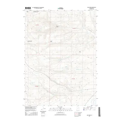
2017 Map of Sage Creek
USGS Topo · Published 2017About this map
Sage Creek and its many tributaries define this high-elevation corner of Rich County, where a network of springs and canyons supports the area's agricultural water needs. The hydrology is particularly complex near Duck Creek Red Spring Duck Cr, illustrating how vital water resources are managed across the undulating terrain. Prominent landmarks like Hogback Ridge and Red Knoll provide orientation within the vast open space, while numerous named water sources such as Rabbit Spring, Rich Spring, and Upper Sage Creek Spring dot the landscape. The presence of the Sage Cr Canal in the southeast corner marks the transition from natural drainage to engineered irrigation, a common feature in Utah's rural land use. The map also traces the winding paths of Sixmile Cr and N Fork Sage Cr through deep draws like Mahogany Canyon and Pine Canyon.
Find a feature on this map
30 named features on this map. Tap any name to fly to it.
Don’t see what you’re looking for? This feature index may not catch every label — zoom into the map to look around manually.
Map Details
Editions of this 2017 Sage Creek Map
This is the sole edition of this map. No revisions or reprints were ever made.
Other maps of this area

1912 · Randolph
USGS Topo · 1:125,000

1954 · Ogden
USGS Topo · 1:250,000

1958 · Ogden
USGS Topo · 1:250,000

1960 · Ogden
USGS Topo · 1:250,000

1968 · Rex Peak
USGS Topo · 1:24,000

1968 · Randolph
USGS Topo · 1:24,000

1969 · Sheeppen Creek
USGS Topo · 1:24,000
1969 · Leefe
USGS Topo · 1:24,000
1969 · South Lake
USGS Topo · 1:24,000
1969 · Bear Lake South
USGS Topo · 1:24,000