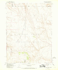
1966 Map of Sage Hen Hills
USGS Topo · Published 1969About this map
The Charles Sheldon Antelope Range defines this high-desert landscape along the state line between Nevada and Oregon during the mid-1960s. This survey, compiled from 1965 aerial photography, documents a remote wilderness managed for wildlife conservation, where topographical landmarks like Springs Table and Horse Heaven rise above the surrounding terrain. The map captures the complex administrative boundaries of the era, where Harney, Washoe, and Humboldt counties meet near the Oregon-Nevada border. A few isolated water sources, including Rock Spring and a simple Spring, serve as vital points for livestock and wildlife across the North Antelope Range. Evidence of human activity is sparse, limited primarily to a network of unimproved routes such as the Jeep Trail that wind through Catnip Canyon toward the summit of Catnip Mountain.
Find a feature on this map
15 named features on this map. Tap any name to fly to it.
Don’t see what you’re looking for? This feature index may not catch every label — zoom into the map to look around manually.
Map Details
Editions of this 1966 Sage Hen Hills Map
2 editions found
Other maps of this area

1889 · Long Valley
USGS Topo · 1:250,000

1954 · Vya
USGS Topo · 1:250,000

1955 · Adel
USGS Topo · 1:250,000

1957 · Adel
USGS Topo · 1:250,000

1958 · Vya
USGS Topo · 1:250,000

1958 · Adel
USGS Topo · 1:250,000

1962 · Vya
USGS Topo · 1:250,000

1962 · Adel
USGS Topo · 1:250,000

1966 · Catnip Canyon
USGS Topo · 1:24,000

1966 · Swan Lake
USGS Topo · 1:24,000