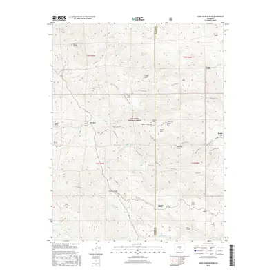
2016 Map of Saint Charles Peak
USGS Topo · Published 2016About this map
San Isabel National Forest dominates this high-altitude landscape along the border of Custer and Pueblo counties. The terrain is defined by a series of prominent peaks and drainage systems, most notably Saint Charles Peak and the Greenhill Divide. Settlement is concentrated near Fairview and the Beulah Valley, while much of the interior remains accessible only via an extensive network of footpaths. These include the Silver Circle Trail, Middle Creek Trail, and the St Charles Trail, which trace the complex topography of canyons and draws. Historical land use is evidenced by several named meadows and parks, such as Burris Meadow, Soldier Park, and Simonson Meadow, suggesting a long history of grazing and transit through these high-country basins. Water features like Eagle Scout Lake Reservoir and numerous creeks, including Squirrel Cr and Ophir Cr, highlight the vital watershed role of this mountain range.
Find a feature on this map
61 named features on this map. Tap any name to fly to it.
Don’t see what you’re looking for? This feature index may not catch every label — zoom into the map to look around manually.
Map Details
Editions of this 2016 Saint Charles Peak Map
This is the sole edition of this map. No revisions or reprints were ever made.
Other maps of this area

1889 · Canon City
USGS Topo · 1:125,000

1889 · Huerfano Park
USGS Topo · 1:125,000

1891 · Walsenburg
USGS Topo · 1:125,000

1891 · Pueblo
USGS Topo · 1:125,000

1892 · Huerfano Park
USGS Topo · 1:125,000

1892 · Canon City
USGS Topo · 1:125,000

1894 · Walsenburg
USGS Topo · 1:125,000

1894 · Pueblo
USGS Topo · 1:125,000

1896 · Pueblo
USGS Topo · 1:125,000

1897 · Pueblo
USGS Topo · 1:125,000