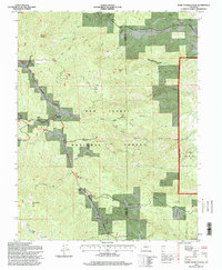
1994 Map of Saint Charles Peak
USGS Topo · Published 1998About this map
Saint Charles Peak dominates the southern reaches of this mid-1990s survey, marking a rugged high point within the San Isabel National Forest. The landscape is a network of drainage basins and ridges, where the Saint Charles River and Ophir Creek carve through the terrain. Evidence of regional history and early travel is preserved through the Frontier Historic Trail and the Greenhorn Highway, which trace the difficult topography.
Find a feature on this map
41 named features on this map. Tap any name to fly to it.
Don’t see what you’re looking for? This feature index may not catch every label — zoom into the map to look around manually.
Map Details
Editions of this 1994 Saint Charles Peak Map
This is the sole edition of this map. No revisions or reprints were ever made.
Other maps of this area

1889 · Canon City
USGS Topo · 1:125,000

1889 · Huerfano Park
USGS Topo · 1:125,000

1891 · Walsenburg
USGS Topo · 1:125,000

1891 · Pueblo
USGS Topo · 1:125,000

1892 · Huerfano Park
USGS Topo · 1:125,000

1892 · Canon City
USGS Topo · 1:125,000

1894 · Walsenburg
USGS Topo · 1:125,000

1894 · Pueblo
USGS Topo · 1:125,000

1896 · Pueblo
USGS Topo · 1:125,000

1897 · Pueblo
USGS Topo · 1:125,000