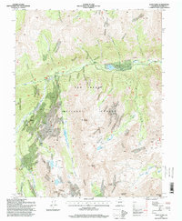
1994 Map of Saint Elmo
USGS Topo · Published 1998About this map
Saint Elmo and the high-altitude mining settlements of the Sawatch Range are captured here during a 1994 field revision. This landscape in the San Isabel National Forest is defined by steep glacial valleys and a legacy of hard-rock extraction, evidenced by numerous mines and prospects scattered across peaks like Chrysolite Mountain and Grizzly Mountain. The corridor along Chalk Creek serves as the primary artery, connecting the sites of Iron City, Romley, and Hancock. Local history is anchored by the Cemetery at Iron City and a smaller Cem near Alpine. High-country water sources such as Grizzly Lake, Pomeroy Lake, and Baldwin Lake dot the upper basins, while a network of 4wd tracks traces the old routes used to reach remote mineral claims above timberline.
Find a feature on this map
43 named features on this map. Tap any name to fly to it.
Don’t see what you’re looking for? This feature index may not catch every label — zoom into the map to look around manually.
Map Details
Editions of this 1994 Saint Elmo Map
This is the sole edition of this map. No revisions or reprints were ever made.
Other maps of this area

1940 · Garfield
USGS Topo · 1:62,500

1945 · Garfield
USGS Topo · 1:62,500

1955 · Buena Vista
USGS Topo · 1:62,500

1955 · Mount Harvard
USGS Topo · 1:62,500

1956 · Poncha Springs
USGS Topo · 1:62,500

1956 · Montrose
USGS Topo · 1:250,000

1959 · Montrose
USGS Topo · 1:250,000

1960 · Montrose
USGS Topo · 1:250,000

1968 · Montrose
USGS Topo · 1:250,000

1982 · Buena Vista West
USGS Topo · 1:24,000