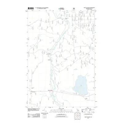
2011 Map of Saint Jacques
USGS Topo · Published 2011About this map
Saint Jacques and Nahma Junction anchor this Delta County landscape, where the winding Sturgeon River carves a path through northern Michigan's forested interior. The map documents a territory defined by its water and recreational resources, featuring the expansive Moss Lake and its smaller counterpart, Little Moss Lake. For genealogists and local historians, the inclusion of Saint Jacques' Cemetery and Isabella Cemetery provides critical location data for family research. Public lands are well-represented by the Mormon Creek Picnic Grounds and Flowing Well Campground, while industrial and safety history is noted at the Moss Lake Lookout Tower. The drainage network is particularly dense, including Germaine Creek, Bull Run, and the Southwest Branch Fishdam River, showing how these waterways shaped the placement of infrastructure like the Fourteenmile Bridge.
Find a feature on this map
26 named features on this map. Tap any name to fly to it.
Don’t see what you’re looking for? This feature index may not catch every label — zoom into the map to look around manually.
Map Details
Editions of this 2011 Saint Jacques Map
This is the sole edition of this map. No revisions or reprints were ever made.
Other maps of this area

1932 · Rapid River NE
USGS Topo · 1:31,680

1932 · Garden NW and SW
USGS Topo · 1:31,680

1932 · Skeels Lake SE
USGS Topo · 1:31,680

1932 · Garden SE
USGS Topo · 1:31,680

1932 · Trenary SE
USGS Topo · 1:31,680

1932 · Rapid River SE
USGS Topo · 1:31,680

1932 · Skeels Lake NW and SW
USGS Topo · 1:31,680

1932 · Garden NE
USGS Topo · 1:31,680

1954 · Escanaba
USGS Topo · 1:250,000

1957 · Escanaba
USGS Topo · 1:250,000