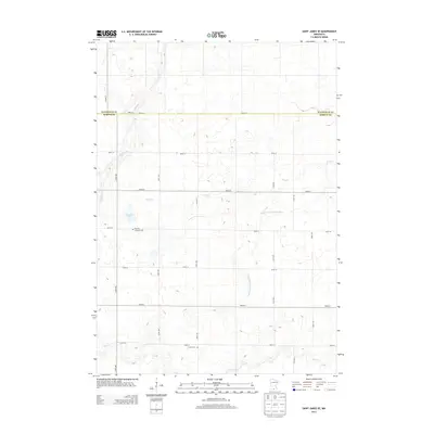
2013 Map of Saint James SE
USGS Topo · Published 2013About this map
The county line between Watonwan and Martin counties bisects this agricultural landscape, defined by a rectilinear grid of rural roads such as 250th ST and 130th Ave. The terrain is characterized by a high density of small wetland pockets and glacial depressions, many of which feed into the meandering channels of Willow Cr, Mink Cr, and Elm Cr. These natural watercourses are supplemented by significant drainage infrastructure, including the long, straight cut of Judicial Ditch Number Sixty, reflecting the area's intensive land management for farming.
Find a feature on this map
22 named features on this map. Tap any name to fly to it.
Don’t see what you’re looking for? This feature index may not catch every label — zoom into the map to look around manually.
Map Details
Editions of this 2013 Saint James SE Map
This is the sole edition of this map. No revisions or reprints were ever made.
Other maps of this area

1954 · Fairmont
USGS Topo · 1:250,000

1958 · Fairmont
USGS Topo · 1:250,000

1967 · Truman
USGS Topo · 1:24,000

1967 · Lewisville
USGS Topo · 1:24,000

1967 · Fairmont
USGS Topo · 1:24,000

1970 · St James SE
USGS Topo · 1:24,000
1970 · St James West
USGS Topo · 1:24,000

1970 · Trimont
USGS Topo · 1:24,000
1970 · St James East
USGS Topo · 1:24,000

1970 · Welcome
USGS Topo · 1:24,000