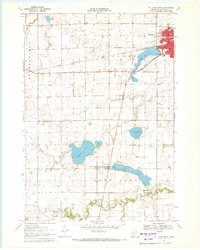
1970 Map of St James West
USGS Topo · Published 1972About this map
St James serves as the focal point of this 1970 survey, where the Chicago and North Western railroad forms a distinct industrial corridor through the community. The map illustrates the town's transition from the dense street grid near the High Sch and Po to the recreational spaces of Memorial Park along the shores of St James Lake. To the south, the landscape is defined by its glacial hydrology, with Kansas Lake and Long Lake providing significant landmarks for local navigation and drainage.
Find a feature on this map
41 named features on this map. Tap any name to fly to it.
Don’t see what you’re looking for? This feature index may not catch every label — zoom into the map to look around manually.
Map Details
Editions of this 1970 St James West Map
2 editions found
Other maps of this area

1953 · New Ulm
USGS Topo · 1:250,000

1954 · Fairmont
USGS Topo · 1:250,000

1957 · New Ulm
USGS Topo · 1:250,000

1958 · New Ulm
USGS Topo · 1:250,000

1958 · Fairmont
USGS Topo · 1:250,000

1967 · New Ulm
USGS Topo · 1:250,000

1967 · Godahl
USGS Topo · 1:24,000

1967 · Darfur
USGS Topo · 1:24,000
1967 · La Salle
USGS Topo · 1:24,000

1970 · St James SE
USGS Topo · 1:24,000