
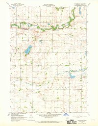
1967 Map of Darfur
USGS Topo · Published 1968About this map
The prairie landscape of Darfur is defined by a dense network of township roads and agricultural development at the intersection of Watonwan, Brown, and Cottonwood counties. The Chicago and North Western railroad cuts diagonally across the terrain, serving as the primary transport corridor for this farming region. Significant riparian and conservation areas are visible, notably the Wood Lake State Wildlife Management Area and the Mulligan State Wildlife Management Area, which provide a contrast to the geometric section lines of the surrounding townships.
Find a feature on this map
25 named features on this map. Tap any name to fly to it.
Don’t see what you’re looking for? This feature index may not catch every label — zoom into the map to look around manually.
Map Details
Editions of this 1967 Darfur Map
This is the sole edition of this map. No revisions or reprints were ever made.
Other maps of this area

1953 · New Ulm
USGS Topo · 1:250,000

1954 · Fairmont
USGS Topo · 1:250,000

1957 · New Ulm
USGS Topo · 1:250,000

1958 · New Ulm
USGS Topo · 1:250,000

1958 · Fairmont
USGS Topo · 1:250,000

1967 · New Ulm
USGS Topo · 1:250,000

1967 · Lake Hanska West
USGS Topo · 1:24,000

1967 · Springfield
USGS Topo · 1:24,000

1967 · Godahl
USGS Topo · 1:24,000
1967 · Leavenworth
USGS Topo · 1:24,000