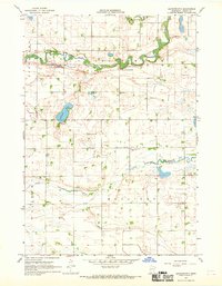
1967 Map of Leavenworth
USGS Topo · Published 1969About this map
The meandering Cottonwood River carves a deep valley through this agricultural landscape in Brown County, anchoring the small settlement of Leavenworth. Surveyed in the late 1960s, the map reveals a region defined by its watercourses and rural infrastructure, from the winding Sleepy Eye Creek in the north to the Little Cottonwood River further south. The land is divided into the distinct townships of Burnstown, Leavenworth, Bashaw, and Mulligan, each dotted with farmsteads and local landmarks. Genealogists and local historians can locate specific community points of interest, such as School No 210, a rural Townhall, and a localized Cem (cemetery). The terrain also shows the modifications of the era, including the County Ditch No 28-1 and several scattered Gravel Pits, illustrating the local industry and drainage efforts essential to Minnesota prairie farming.
Find a feature on this map
15 named features on this map. Tap any name to fly to it.
Don’t see what you’re looking for? This feature index may not catch every label — zoom into the map to look around manually.
Map Details
Editions of this 1967 Leavenworth Map
This is the sole edition of this map. No revisions or reprints were ever made.
Other maps of this area

1953 · Morgan
USGS Topo · 1:62,500

1953 · New Ulm
USGS Topo · 1:250,000

1957 · New Ulm
USGS Topo · 1:250,000

1958 · New Ulm
USGS Topo · 1:250,000

1964 · Sleepy Eye
USGS Topo · 1:24,000

1967 · New Ulm
USGS Topo · 1:250,000

1967 · Lake Hanska West
USGS Topo · 1:24,000

1967 · Springfield
USGS Topo · 1:24,000

1967 · Godahl
USGS Topo · 1:24,000

1967 · Darfur
USGS Topo · 1:24,000