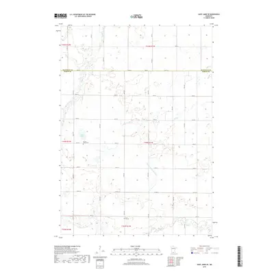
2019 Map of Saint James SE
USGS Topo · Published 2019About this map
Round Lake sits near the western border of this agricultural landscape in Martin County, marking a rare open water feature in a region defined by its sophisticated drainage and field patterns. The map highlights the transition between Watonwan and Martin counties, where section lines are traced by an extensive network of local roads including Co Hwy 27 and Co Hwy 44. For genealogists and local historians, the presence of the Waverly Lutheran Cem and North Star Cem provide specific points of interest for family research. The terrain is deeply influenced by water management, seen in the path of the Judicial Ditch Number Sixty which supplements natural waterways like Mink Cr and Elm Cr. This survey illustrates the modern grid-based settlement pattern that dominates the southern Minnesota prairie.
Find a feature on this map
34 named features on this map. Tap any name to fly to it.
Don’t see what you’re looking for? This feature index may not catch every label — zoom into the map to look around manually.
Map Details
Editions of this 2019 Saint James SE Map
This is the sole edition of this map. No revisions or reprints were ever made.
Other maps of this area

1954 · Fairmont
USGS Topo · 1:250,000

1958 · Fairmont
USGS Topo · 1:250,000

1967 · Truman
USGS Topo · 1:24,000

1967 · Lewisville
USGS Topo · 1:24,000

1967 · Fairmont
USGS Topo · 1:24,000

1970 · St James SE
USGS Topo · 1:24,000
1970 · St James West
USGS Topo · 1:24,000

1970 · Trimont
USGS Topo · 1:24,000
1970 · St James East
USGS Topo · 1:24,000

1970 · Welcome
USGS Topo · 1:24,000