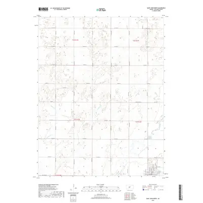
2018 Map of Saint John North
USGS Topo · Published 2018About this map
St. John occupies the southeast corner of this Stafford County landscape, serving as a hub for the surrounding agricultural plains. The town's grid is clearly defined, featuring a Po and a network of residential and commercial avenues including W 4th Ave and E 5th Ave. North and west of the settlement, the terrain is shaped by several drainage systems, most notably Wild Horse Cr and Little Wild Horse Cr, which wind through the township ranges. The hydrological pattern is further defined by Bear Cr and the larger Rattlesnake Cr in the south, suggesting a landscape managed for drainage and irrigation. A dense section-line road network, including names like Eden Valley Rd and Zook RD, illustrates the systematic land division that has governed this part of Kansas since its initial survey.
Find a feature on this map
31 named features on this map. Tap any name to fly to it.
Don’t see what you’re looking for? This feature index may not catch every label — zoom into the map to look around manually.
Map Details
Editions of this 2018 Saint John North Map
This is the sole edition of this map. No revisions or reprints were ever made.
Other maps of this area

1891 · Great Bend
USGS Topo · 1:125,000

1892 · Pratt
USGS Topo · 1:125,000

1893 · Great Bend
USGS Topo · 1:125,000

1894 · Pratt
USGS Topo · 1:125,000

1955 · Great Bend
USGS Topo · 1:250,000

1955 · Pratt
USGS Topo · 1:250,000

1957 · Great Bend
USGS Topo · 1:250,000

1958 · Great Bend
USGS Topo · 1:250,000

1959 · Pratt
USGS Topo · 1:250,000
1969 · Radium
USGS Topo · 1:24,000