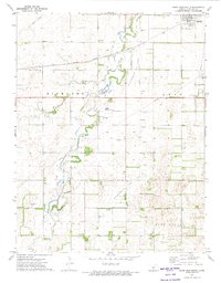
1972 Map of Saint John South
USGS Topo · Published 1974About this map
Rattlesnake Creek meanders through the heart of the Kansas prairie south of Saint John in this early 1970s survey. The landscape is defined by the intersection of traditional agriculture and a burgeoning petroleum industry, evidenced by the extensive Rattlesnake SE Oil Field and Rattlesnake SW Oil Field that dot the southern townships. The Atchison Topeka and Santa Fe railroad cuts a diagonal line across the northern section, connecting the local economy to broader markets.
Find a feature on this map
20 named features on this map. Tap any name to fly to it.
Don’t see what you’re looking for? This feature index may not catch every label — zoom into the map to look around manually.
Map Details
Editions of this 1972 Saint John South Map
This is the sole edition of this map. No revisions or reprints were ever made.
Other maps of this area

1891 · Great Bend
USGS Topo · 1:125,000

1892 · Pratt
USGS Topo · 1:125,000

1893 · Great Bend
USGS Topo · 1:125,000

1894 · Pratt
USGS Topo · 1:125,000

1955 · Great Bend
USGS Topo · 1:250,000

1955 · Pratt
USGS Topo · 1:250,000

1957 · Great Bend
USGS Topo · 1:250,000

1958 · Great Bend
USGS Topo · 1:250,000

1959 · Pratt
USGS Topo · 1:250,000
1971 · Hudson
USGS Topo · 1:24,000