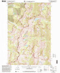
1998 Map of Saint Joseph Peak
USGS Topo · Published 2002About this map
Saint Joseph Peak and Bass Peak anchor this high-altitude landscape along the border of Montana and Idaho, where multiple national forests converge. The terrain is defined by glacier-carved basins and numerous alpine water bodies, including Sweeney Lake, Bass Lake, and Moose Lake. These features are protected within the vast boundaries of the Lolo National Forest and the Selway Bitterroot Wilderness, preserving a high-country environment that has seen minimal development.
Find a feature on this map
34 named features on this map. Tap any name to fly to it.
Don’t see what you’re looking for? This feature index may not catch every label — zoom into the map to look around manually.
Map Details
Editions of this 1998 Saint Joseph Peak Map
This is the sole edition of this map. No revisions or reprints were ever made.
Other maps of this area

1901 · Hamilton
USGS Topo · 1:125,000

1912 · Missoula
USGS Topo · 1:125,000

1956 · Hamilton
USGS Topo · 1:250,000

1959 · Hamilton
USGS Topo · 1:250,000

1960 · Hamilton
USGS Topo · 1:250,000

1964 · Hamilton
USGS Topo · 1:250,000

1964 · Dick Creek
USGS Topo · 1:24,000

1964 · West Fork Butte
USGS Topo · 1:24,000

1964 · St. Joseph Peak
USGS Topo · 1:24,000
1964 · Ranger Peak
USGS Topo · 1:24,000