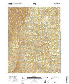
2019 Map of Saint Joy
USGS Topo · Published 2019About this map
Saint Joy serves as the central settlement in this Buckingham County landscape, where the rural character is defined by a dense network of watercourses and winding country roads. The local geography is etched by numerous streams including Austin Cr, Meadow Cr, and the Walton Fork, which converge toward the N River at the eastern edge. For those researching family history or local land use, the Saint Joy Cem provides a significant anchor near the town center.
Find a feature on this map
42 named features on this map. Tap any name to fly to it.
Don’t see what you’re looking for? This feature index may not catch every label — zoom into the map to look around manually.
Map Details
Editions of this 2019 Saint Joy Map
This is the sole edition of this map. No revisions or reprints were ever made.
Other maps of this area

1892 · Buckingham
USGS Topo · 1:125,000

1892 · Appomattox
USGS Topo · 1:125,000

1947 · Roanoke
USGS Topo · 1:250,000

1958 · Appomattox
USGS Topo · 1:62,500

1958 · Pamplin City
USGS Topo · 1:62,500

1959 · Roanoke
USGS Topo · 1:250,000

1961 · Shipman
USGS Topo · 1:62,500

1961 · Buckingham
USGS Topo · 1:62,500

1963 · Roanoke
USGS Topo · 1:250,000

1967 · Andersonville
USGS Topo · 1:24,000