
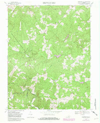
1967 Map of Andersonville
USGS Topo · Published 1971About this map
The Willis River and its numerous tributaries, including Brickyard Branch and Little Willis River, carve through the rolling timberlands of central Virginia. In the late 1960s, this landscape was defined by its managed woodlands, notably the Lee Experimental Forest in the north and a portion of the Appomattox-Buckingham State Forest to the west. Small agricultural communities such as Andersonville and New Store anchor the road network, which is sparsely populated but dotted with rural sanctuaries like Second Liberty Ch and Bethel Ch.
Find a feature on this map
26 named features on this map. Tap any name to fly to it.
Don’t see what you’re looking for? This feature index may not catch every label — zoom into the map to look around manually.
Map Details
Editions of this 1967 Andersonville Map
Other maps of this area

1891 · Palmyra
USGS Topo · 1:125,000

1891 · Farmville
USGS Topo · 1:125,000

1892 · Buckingham
USGS Topo · 1:125,000

1892 · Appomattox
USGS Topo · 1:125,000

1893 · Farmville
USGS Topo · 1:125,000

1895 · Palmyra
USGS Topo · 1:125,000

1897 · Palmyra
USGS Topo · 1:125,000

1947 · Roanoke
USGS Topo · 1:250,000

1950 · Dillwyn
USGS Topo · 1:62,500

1958 · Farmville
USGS Topo · 1:62,500