
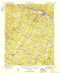
1950 Map of Dillwyn
USGS Topo · Published 1950About this map
The James River corridor defines the northern edge of this Piedmont landscape, where the Chesapeake and Ohio railroad follows the riverbank past historic estates like Bremo Mansion and Lower Bremo Mansion. Inland, the economy of central Virginia is etched into the terrain through a network of small settlements and industrial sites, including the Quarry near Arvonia and an abandoned gold mine south of Dillwyn. The map reveals a dense social infrastructure of the mid-century, from the Buckingham County School to numerous country churches like Mourning Valley Church and Bright Morning Star Church. The southern reach of the survey is anchored by the Cumberland State Forest and the Willis River, showing a transition from the river-oriented commerce of New Canton to the timber and tobacco lands of the interior.
Find a feature on this map
102 named features on this map. Tap any name to fly to it.
Don’t see what you’re looking for? This feature index may not catch every label — zoom into the map to look around manually.
Map Details
Editions of this 1950 Dillwyn Map
2 editions found
Other maps of this area

1891 · Palmyra
USGS Topo · 1:125,000

1891 · Farmville
USGS Topo · 1:125,000

1892 · Buckingham
USGS Topo · 1:125,000

1892 · Appomattox
USGS Topo · 1:125,000

1893 · Farmville
USGS Topo · 1:125,000

1895 · Palmyra
USGS Topo · 1:125,000

1897 · Palmyra
USGS Topo · 1:125,000

1929 · Covesville
USGS Topo · 1:62,500

1935 · Covesville
USGS Topo · 1:62,500

1943 · Scottsville
USGS Topo · 1:62,500