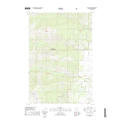
2020 Map of Saint Mary Peak
USGS Topo · Published 2020About this map
Bitterroot National Forest dominates this section of the Bitterroot Range, defined by the towering Saint Mary Peak and nearby Little St Joe. This 2020 survey illustrates a landscape primarily managed for conservation and recreation, where high-altitude water bodies like Holloway Lake and Lappi Lake feed a network of drainage systems including S Fork Sweeney Creek and Kootenai Creek. While much of the western terrain remains high-elevation wilderness, the eastern fringe shows the gradual transition toward the valley floor through a developed network of forest access and residential roads. Notable pathways like the Sweeney Creek Trail and Ecology Trail provide access to the backcountry, while named features such as Kennedy Gulch and Million Gulch provide specific landmarks for local history and geographic orientation.
Find a feature on this map
48 named features on this map. Tap any name to fly to it.
Don’t see what you’re looking for? This feature index may not catch every label — zoom into the map to look around manually.
Map Details
Editions of this 2020 Saint Mary Peak Map
This is the sole edition of this map. No revisions or reprints were ever made.
Other maps of this area

1901 · Hamilton
USGS Topo · 1:125,000

1912 · Missoula
USGS Topo · 1:125,000

1956 · Hamilton
USGS Topo · 1:250,000

1959 · Hamilton
USGS Topo · 1:250,000

1960 · Hamilton
USGS Topo · 1:250,000

1964 · Hamilton
USGS Topo · 1:250,000

1964 · Dick Creek
USGS Topo · 1:24,000

1964 · St. Joseph Peak
USGS Topo · 1:24,000
1966 · Gash Point
USGS Topo · 1:24,000
1967 · Carlton Lake
USGS Topo · 1:24,000