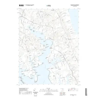
2019 Map of Saint Marys City
USGS Topo · Published 2019About this map
Saint Marys City and the surrounding Chesapeake tidewater are defined by an intricate network of creeks and points along the Saint Marys River. This 2019 survey captures the modern landscape of the lower Potomac heritage region, where historical naming conventions persist alongside active aviation sites like West St Mary's Airport and the Webster Naval Outlying Field. The geography is dominated by deeply indented shorelines, including Milburn Creek, Smith Creek, and Jutland Creek, which carve into landmasses like Saint Inigoes Neck. Small settlements such as Great Mills, Drayden, and Beachville are connected by Point Lookout Rd, while the southern reaches extend toward the Saint George Island Bridge and the marshy expanses of Saint George Island. The presence of many family-named landmarks like Rose Croft Point and Chancellor Point highlights the enduring residential and maritime heritage of the county.
Find a feature on this map
82 named features on this map. Tap any name to fly to it.
Don’t see what you’re looking for? This feature index may not catch every label — zoom into the map to look around manually.
Map Details
Editions of this 2019 Saint Marys City Map
This is the sole edition of this map. No revisions or reprints were ever made.
Other maps of this area

1892 · Leonardtown
USGS Topo · 1:62,500

1892 · Drum Point
USGS Topo · 1:62,500

1892 · Piney Point
USGS Topo · 1:62,500

1894 · Piney Point
USGS Topo · 1:62,500

1894 · Point Lookout
USGS Topo · 1:62,500

1895 · Leonardtown
USGS Topo · 1:62,500

1895 · Nomini
USGS Topo · 1:125,000

1895 · Piney Point
USGS Topo · 1:62,500

1898 · Nomini
USGS Topo · 1:125,000

1898 · St. Marys
USGS Topo · 1:125,000