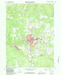
1969 Map of Saint Marys
USGS Topo · Published 1984About this map
Saint Marys serves as the industrial and civic anchor of this Elk County landscape, where the Conrail lines intersect a dense grid of streets like Brussels St and Washington St. The settlement pattern reveals a deeply established community with numerous religious and educational institutions, including Saint Marys Church, Sacred Heart Church, and the Saint Marys Area High Sch. Beyond the residential core of Lynchville and Grandview, the terrain is defined by the narrow valleys of Elk Creek and Silver Run, much of which is preserved within State Game Lands No 25. This era shows a transition from traditional resource extraction, evidenced by scattered Gas Wells and Gravel Pits, toward more modern infrastructure like the Filtration Plant and Saint Marys Airport. Unique landmarks such as the Decker Chapel and the Elk Haven County Home reflect the specific social and local history of the Benzinger and Jay township areas.
Find a feature on this map
70 named features on this map. Tap any name to fly to it.
Don’t see what you’re looking for? This feature index may not catch every label — zoom into the map to look around manually.
Map Details
Editions of this 1969 Saint Marys Map
3 editions found
Other maps of this area

1935 · Mt. Jewett
USGS Topo · 1:48,000

1940 · Mt. Jewett
USGS Topo · 1:62,500

1941 · Benezette
USGS Topo · 1:62,500

1941 · Ridgway
USGS Topo · 1:62,500

1943 · Benezette
USGS Topo · 1:62,500

1944 · Ridgway
USGS Topo · 1:62,500

1948 · Crosby
USGS Topo · 1:62,500

1948 · Wildwood Fire Tower
USGS Topo · 1:24,000
1950 · Wildwood Fire Tower
USGS Topo · 1:24,000

1957 · Warren
USGS Topo · 1:250,000