1954 Map of Saint Onge
USGS Topo · Published 1959About this map
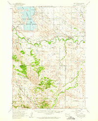
The Belle Fourche Reservoir and its massive irrigation infrastructure dominate the northern landscape of this mid-century Western South Dakota survey. A complex network of water management features, including the Inlet Canal, South Lateral, and Indian Creek Lateral, supports the agricultural valley surrounding Nisland and Fruitdale. These engineering works were central to the region’s development, feeding the thirsty lands bordering the Belle Fourche River.
Find a feature on this map
53 named features on this map. Tap any name to fly to it.
Don’t see what you’re looking for? This feature index may not catch every label — zoom into the map to look around manually.
Map Details
Editions of this 1954 Saint Onge Map
This is the sole edition of this map. No revisions or reprints were ever made.
Other maps of this area

1893 · Rapid
USGS Topo · 1:125,000

1894 · Deadwood
USGS Topo · 1:125,000

1898 · Rapid
USGS Topo · 1:125,000

1899 · Sturgis
USGS Topo · 1:62,500

1900 · Spearfish
USGS Topo · 1:62,500

1901 · Deadwood
USGS Topo · 1:125,000

1903 · Rapid
USGS Topo · 1:125,000

1905 · Saint Onge
USGS Topo · 1:62,500
1905 · Indian
USGS Topo · 1:62,500

1906 · Two Top
USGS Topo · 1:62,500