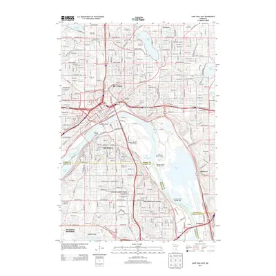
2013 Map of Saint Paul East
USGS Topo · Published 2013About this map
The Mississippi River carves a deep industrial and geographical path through this 2013 record of the Twin Cities' eastern reaches, separating St Paul from its southern neighbors. The riverfront is dominated by logistics and infrastructure, including the St. Paul Downtown Airport / Holman Field and the Metro Saint Paul Water Treatment Facility near the expansive Pigs Eye Lake. This landscape is particularly rich for genealogical research, documenting numerous burial grounds such as Oakland Cem, Elmhurst Cem, and several smaller religious sites like the Sons of Moses Cem. Cultural landmarks like Cathedral Hill and the James Hill Reference Library overlook the river valley, while the eastern residential expansion is evidenced by the growth around Lake Phalen and the suburban communities of Highwood and Gladstone.
Find a feature on this map
80 named features on this map. Tap any name to fly to it.
Don’t see what you’re looking for? This feature index may not catch every label — zoom into the map to look around manually.
Map Details
Editions of this 2013 Saint Paul East Map
This is the sole edition of this map. No revisions or reprints were ever made.
Other maps of this area

1896 · St. Paul
USGS Topo · 1:62,500

1902 · White Bear
USGS Topo · 1:62,500

1946 · Hudson
USGS Topo · 1:62,500

1948 · Stillwater
USGS Topo · 1:62,500

1949 · Hudson
USGS Topo · 1:62,500

1949 · Stillwater
USGS Topo · 1:62,500

1949 · Lake Elmo
USGS Topo · 1:24,000

1950 · Lake Elmo
USGS Topo · 1:24,000

1950 · St Paul Park
USGS Topo · 1:24,000

1951 · St Paul Park
USGS Topo · 1:24,000