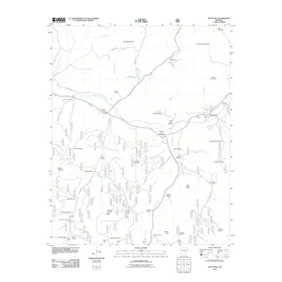
2011 Map of Saint Paul
USGS Topo · Published 2011About this map
Saint Paul and the nearby settlements of Combs and Brashears anchor this mountainous region of Madison County, where the upper reaches of the White River begin their winding course. The map documents a landscape defined by sharp elevation changes, from the heights of Fly Gap Mountain and Hare Mountain down into deep hollows such as Wolf Pen Hollow and Tanyard Hollow. The density of family and community cemeteries, including Riverside Cemetery, Prater Cemetery, and Van Brunt Cemetery, provides a significant record for genealogical research in these Ozark highlands. Rural infrastructure is represented by the Combs Post Office and the Fly Gap Lookout Tower, while a complex network of forest and county roads like County Rd-335 provides access to the timbered ridges and creek bottoms of Mill Creek and Fleming Creek.
Find a feature on this map
134 named features on this map. Tap any name to fly to it.
Don’t see what you’re looking for? This feature index may not catch every label — zoom into the map to look around manually.
Map Details
Editions of this 2011 Saint Paul Map
This is the sole edition of this map. No revisions or reprints were ever made.
Other maps of this area

1879 · Cravens
USGS Topo · 1:62,500

1887 · Watalula
USGS Topo · 1:62,500

1906 · Batson
USGS Topo · 1:62,500

1939 · Watalula
USGS Topo · 1:62,500

1943 · St. Paul
USGS Topo · 1:62,500

1946 · St. Paul
USGS Topo · 1:62,500

1956 · Russellville
USGS Topo · 1:250,000

1964 · Russellville
USGS Topo · 1:250,000
1973 · Witter
USGS Topo · 1:24,000
1973 · Durham
USGS Topo · 1:24,000