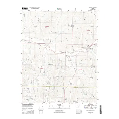
2014 Map of Saint Paul
USGS Topo · Published 2014About this map
Saint Paul sits at the eastern edge of this landscape along the White River, serving as a focal point for the mountain communities of southeastern Madison County. The terrain is defined by deep hollows and high ridges typical of the Ozark National Forest, where the upper reaches of the river and its many tributaries, including Greasy Cr and Mill Creek, have carved out a complex drainage pattern. The settlement at Brashears and the community of Combs are connected by State Hwy 16, following the natural contours of the valley floor. Numerous family-named cemeteries such as Prater Cem and Van Brunt Cem are scattered across the ridges, providing a clear map of rural family lineage. The presence of the Fly Gap Lookout Tower near McKay Ridge highlights the era's ongoing management of the vast forest lands, while landmarks like Joe Salee Bluff offer distinctive navigational points for the high country.
Find a feature on this map
93 named features on this map. Tap any name to fly to it.
Don’t see what you’re looking for? This feature index may not catch every label — zoom into the map to look around manually.
Map Details
Editions of this 2014 Saint Paul Map
This is the sole edition of this map. No revisions or reprints were ever made.
Other maps of this area

1879 · Cravens
USGS Topo · 1:62,500

1887 · Watalula
USGS Topo · 1:62,500

1906 · Batson
USGS Topo · 1:62,500

1939 · Watalula
USGS Topo · 1:62,500

1943 · St. Paul
USGS Topo · 1:62,500

1946 · St. Paul
USGS Topo · 1:62,500

1956 · Russellville
USGS Topo · 1:250,000

1964 · Russellville
USGS Topo · 1:250,000
1973 · Witter
USGS Topo · 1:24,000
1973 · Durham
USGS Topo · 1:24,000