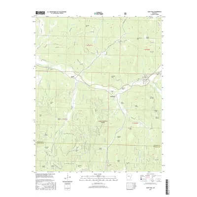
2017 Map of Saint Paul
USGS Topo · Published 2017About this map
The White River winds through the southern Ozark Highlands, anchoring the small valley settlements of St. Paul, Combs, and Brashears. This 2017 survey illustrates the complex topography of Madison County, where steep ridges like Chimney Rock Mtn and Burrell Mtn overlook deep drainage basins such as Hawkins Hollow and Tanyard Hollow. Much of the southern half of the map is dominated by the Ozark National Forest, a landscape marked by an extensive network of recreation paths including the Mill Creek Trail Blue Loop and the Mill Creek Burrell Mtn Loop. Genealogy and local history are well-preserved through numerous family and community burial grounds, from Riverside Cem near the riverbanks to the more secluded Gragar Cem and Morgan Cem, reflecting the early settlement patterns of these mountain hollows.
Find a feature on this map
95 named features on this map. Tap any name to fly to it.
Don’t see what you’re looking for? This feature index may not catch every label — zoom into the map to look around manually.
Map Details
Editions of this 2017 Saint Paul Map
This is the sole edition of this map. No revisions or reprints were ever made.
Other maps of this area

1879 · Cravens
USGS Topo · 1:62,500

1887 · Watalula
USGS Topo · 1:62,500

1906 · Batson
USGS Topo · 1:62,500

1939 · Watalula
USGS Topo · 1:62,500

1943 · St. Paul
USGS Topo · 1:62,500

1946 · St. Paul
USGS Topo · 1:62,500

1956 · Russellville
USGS Topo · 1:250,000

1964 · Russellville
USGS Topo · 1:250,000
1973 · Witter
USGS Topo · 1:24,000
1973 · Durham
USGS Topo · 1:24,000