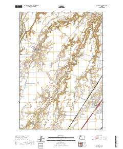
2020 Map of Saint Paul
USGS Topo · Published 2020About this map
French Prairie defines the agricultural character of this landscape, where the fertile land between the Willamette River and the expanding outskirts of Woodburn has supported generations of farming. The map highlights several early settlements and religious centers, including St. Paul and Saint Louis, which remain as core community hubs. Water management is central to the area's development, evidenced by a network of drainage and reservoirs such as McKay Reservoir and Spada Reservoir that feed into the winding Champoeg Cr.
Find a feature on this map
79 named features on this map. Tap any name to fly to it.
Don’t see what you’re looking for? This feature index may not catch every label — zoom into the map to look around manually.
Map Details
Editions of this 2020 Saint Paul Map
This is the sole edition of this map. No revisions or reprints were ever made.
Other maps of this area

1916 · Tualatin
USGS Topo · 1:62,500

1923 · Mount Angel
USGS Topo · 1:62,500

1924 · Mc Minnville
USGS Topo · 1:48,000

1926 · Mc Minnville
USGS Topo · 1:62,500

1939 · Tualatin
USGS Topo · 1:62,500

1940 · McMinnville
USGS Topo · 1:62,500

1940 · Tualatin
USGS Topo · 1:62,500

1940 · Mount Angel
USGS Topo · 1:62,500

1941 · Yamhill
USGS Topo · 1:62,500

1942 · Yamhill
USGS Topo · 1:62,500