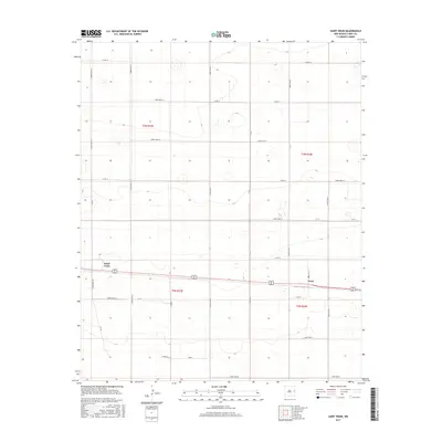
2017 Map of Saint Vrain
USGS Topo · Published 2017About this map
Saint Vrain and Grier anchor this high plains landscape in Curry County, where the rigid geometry of the Public Land Survey System is visible through a dense grid of rural corridors. The map depicts a territory defined by its transition between townships t3n r33e and t2n r34e, where the vast majority of the terrain is organized for agricultural use. This modern survey shows a sophisticated network of named roads, including Curry Road 15, Curry Road 10, and Curry Road 8, which trace the section lines typical of the Llano Estacado region. While much of the area appears as open upland, the presence of Creek Y and scattered depressions indicate the subtle drainage patterns and playa lakes characteristic of the New Mexico eastern plains. This document provides a clear view of how rural infrastructure has evolved to support the small communities and farmsteads established here over a century ago.
Find a feature on this map
37 named features on this map. Tap any name to fly to it.
Don’t see what you’re looking for? This feature index may not catch every label — zoom into the map to look around manually.
Map Details
Editions of this 2017 Saint Vrain Map
This is the sole edition of this map. No revisions or reprints were ever made.
Other maps of this area

1954 · Clovis
USGS Topo · 1:250,000

1957 · Portair
USGS Topo · 1:62,500

1957 · Melrose
USGS Topo · 1:62,500

1957 · Hammond Ranch
USGS Topo · 1:62,500

1958 · Clovis
USGS Topo · 1:250,000

1972 · Melrose East
USGS Topo · 1:24,000

1973 · Field SE
USGS Topo · 1:24,000
1973 · Melrose SE
USGS Topo · 1:24,000

1985 · Portair
USGS Topo · 1:24,000
1985 · Garrett Ranch
USGS Topo · 1:24,000