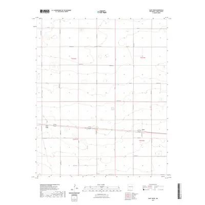
2023 Map of Saint Vrain
USGS Topo · Published 2023About this map
Saint Vrain and Grier anchor this section of Curry County, where the High Plains landscape is defined by a rigorous township-and-range grid. The map shows a transition from the agricultural plateaus of t3n r33e down through the more intricate drainages and depressions of the southern townships. A network of rural routes, including Curry Road AB, Curry Road Z, and Curry Road X, facilitates travel across the sparsely populated terrain, following the section lines established by the Bureau of Land Management. The alignment of Curry Road 12 and Curry Road 9 highlights the functional, rectilinear development typical of this New Mexico ranching and farming region.
Find a feature on this map
25 named features on this map. Tap any name to fly to it.
Don’t see what you’re looking for? This feature index may not catch every label — zoom into the map to look around manually.
Map Details
Editions of this 2023 Saint Vrain Map
This is the sole edition of this map. No revisions or reprints were ever made.
Other maps of this area

1954 · Clovis
USGS Topo · 1:250,000

1957 · Portair
USGS Topo · 1:62,500

1957 · Melrose
USGS Topo · 1:62,500

1957 · Hammond Ranch
USGS Topo · 1:62,500

1958 · Clovis
USGS Topo · 1:250,000

1972 · Melrose East
USGS Topo · 1:24,000

1973 · Field SE
USGS Topo · 1:24,000
1973 · Melrose SE
USGS Topo · 1:24,000

1985 · Portair
USGS Topo · 1:24,000
1985 · Garrett Ranch
USGS Topo · 1:24,000