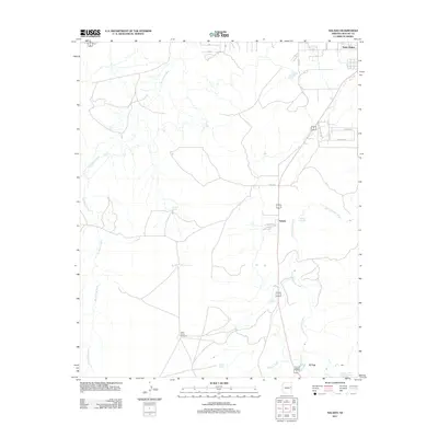
2011 Map of Salado
USGS Topo · Published 2011About this map
The Little Colorado River winds through this high desert corridor of Apache County, serving as the primary geographic anchor for small settlements and ranching operations. Near the northern boundary, the outskirts of Saint Johns mark the edge of the county seat, while further south, the eponymous community of Salado sits at a crossroads of rural routes. The landscape is defined by its water sources, from the seasonal flow of Big Hollow Wash and Chimney Wash to the reliable presence of Salado Springs and Romero Spring. Ranching heritage is evidenced by landmarks such as the White Corral Windmills and Chavez Ranch, while the southern reaches of the map touch upon the waters of Lyman Lake. This survey illustrates a quiet pocket of eastern Arizona where life remains tied to the drainages and springs that sustain the high plateau.
Find a feature on this map
18 named features on this map. Tap any name to fly to it.
Don’t see what you’re looking for? This feature index may not catch every label — zoom into the map to look around manually.
Map Details
Editions of this 2011 Salado Map
This is the sole edition of this map. No revisions or reprints were ever made.
Other maps of this area

1886 · St Johns
USGS Topo · 1:250,000

1892 · St Johns
USGS Topo · 1:250,000

1954 · Saint Johns
USGS Topo · 1:250,000

1955 · Adamana 4 SE
USGS Topo · 1:24,000

1955 · Wolford Springs 3 SW
USGS Topo · 1:24,000

1955 · Hunt
USGS Topo · 1:62,500

1957 · Saint Johns
USGS Topo · 1:250,000

1958 · Saint Johns
USGS Topo · 1:250,000

1962 · Saint Johns
USGS Topo · 1:250,000
1971 · Cerro Hueco
USGS Topo · 1:24,000