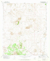
1971 Map of Cerro Hueco
USGS Topo · Published 1973About this map
Cerro Hueco and Cerro Montoso dominate this high-desert landscape in Apache County, captured during a 1971 field check. The area is defined by its water management systems, essential for ranching and survival in the arid Arizona interior. Named water sources like Santa Fe Well, Antelope Well, and Blood Tank are scattered across the terrain, connected by a network of Jeep Trails that navigate the volcanic features. The presence of a Cinder Pit and Borrow Pit near the southern volcanic peaks suggests local material extraction, while Wildcat Creek and Mallory Draw provide the primary drainage patterns for the region. This survey offers a clear view of the rural infrastructure and land use patterns of northeastern Arizona during the early 1970s.
Find a feature on this map
18 named features on this map. Tap any name to fly to it.
Don’t see what you’re looking for? This feature index may not catch every label — zoom into the map to look around manually.
Map Details
Editions of this 1971 Cerro Hueco Map
3 editions found
Other maps of this area

1886 · St Johns
USGS Topo · 1:250,000

1892 · St Johns
USGS Topo · 1:250,000

1954 · Saint Johns
USGS Topo · 1:250,000

1957 · Saint Johns
USGS Topo · 1:250,000

1958 · Saint Johns
USGS Topo · 1:250,000

1962 · Saint Johns
USGS Topo · 1:250,000

1968 · Boundary Butte
USGS Topo · 1:24,000

1968 · Springerville NW
USGS Topo · 1:24,000

1969 · Whiting Knoll
USGS Topo · 1:24,000
1971 · Vernon
USGS Topo · 1:24,000