
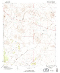
1968 Map of Springerville NW
USGS Topo · Published 1972About this map
The volcanic highlands of eastern Arizona are defined here by distinctive cones and drainage systems during the late 1960s. Cerro Quemado stands as a prominent landmark in a landscape marked by industrial activity at several Cinder Pits, suggesting the extraction of volcanic materials for regional infrastructure. The high-altitude terrain is dissected by Cienega Draw and Carnero Creek, which serve as the primary conduits for seasonal runoff.
Find a feature on this map
18 named features on this map. Tap any name to fly to it.
Don’t see what you’re looking for? This feature index may not catch every label — zoom into the map to look around manually.
Map Details
Editions of this 1968 Springerville NW Map
2 editions found
Other maps of this area

1886 · St Johns
USGS Topo · 1:250,000

1892 · St Johns
USGS Topo · 1:250,000

1954 · Saint Johns
USGS Topo · 1:250,000

1957 · Saint Johns
USGS Topo · 1:250,000

1958 · Saint Johns
USGS Topo · 1:250,000

1962 · Saint Johns
USGS Topo · 1:250,000

1969 · Whiting Knoll
USGS Topo · 1:24,000
1969 · Greer
USGS Topo · 1:24,000
1969 · Eagar
USGS Topo · 1:24,000
1969 · Greens Peak
USGS Topo · 1:24,000