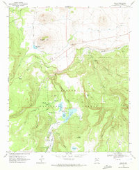
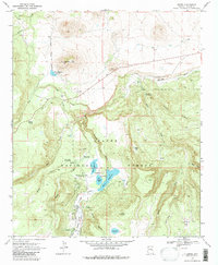
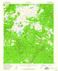
1969 Map of Greer
USGS Topo · Published 1972About this map
The Little Colorado River and its various forks and tributaries define the high-elevation landscape of this Apache County survey from the late 1960s. Central to the map's water management are the Greer Lakes, which include Bunch Reservoir, Tunnel Res, and River Reservoir. These bodies of water, along with the Filler Ditch and the Ellis Wittbank Reservoir near Antelope Mtn, reflect the importance of irrigation and water storage in this part of the Apache National Forest.
Find a feature on this map
40 named features on this map. Tap any name to fly to it.
Don’t see what you’re looking for? This feature index may not catch every label — zoom into the map to look around manually.
Map Details
Editions of this 1969 Greer Map
2 editions found
Other maps of this area

1886 · St Johns
USGS Topo · 1:250,000

1892 · St Johns
USGS Topo · 1:250,000

1922 · Nutrioso
USGS Topo · 1:125,000

1954 · Clifton
USGS Topo · 1:250,000

1954 · Saint Johns
USGS Topo · 1:250,000

1957 · Clifton
USGS Topo · 1:250,000

1957 · Saint Johns
USGS Topo · 1:250,000

1958 · Clifton
USGS Topo · 1:250,000

1958 · Saint Johns
USGS Topo · 1:250,000
1958 · Big Lake
USGS Topo · 1:62,500