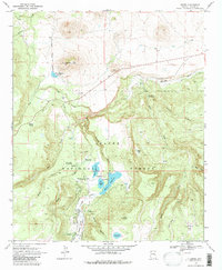
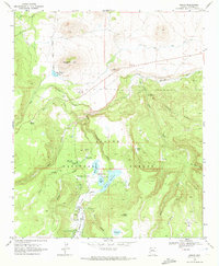
1969 Map of Greer
USGS Topo · Published 1980About this map
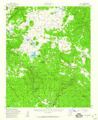
Greer sits at the heart of this high-elevation landscape in the Apache National Forest, where the headwaters of the Little Colorado River gather. The settlement is surrounded by a series of critical water management features, including Bunch Reservoir, Tunnel Res, and the larger River Reservoir, collectively known as the Greer Lakes. These reservoirs and the nearby Gaging Stations illustrate the importance of water control for the region's downstream agriculture and ecosystem during the late 1960s.
Find a feature on this map
39 named features on this map. Tap any name to fly to it.
Don’t see what you’re looking for? This feature index may not catch every label — zoom into the map to look around manually.
Map Details
Editions of this 1969 Greer Map
2 editions found
Other maps of this area

1886 · St Johns
USGS Topo · 1:250,000

1892 · St Johns
USGS Topo · 1:250,000

1922 · Nutrioso
USGS Topo · 1:125,000

1954 · Clifton
USGS Topo · 1:250,000

1954 · Saint Johns
USGS Topo · 1:250,000

1957 · Clifton
USGS Topo · 1:250,000

1957 · Saint Johns
USGS Topo · 1:250,000

1958 · Clifton
USGS Topo · 1:250,000

1958 · Saint Johns
USGS Topo · 1:250,000
1958 · Big Lake
USGS Topo · 1:62,500