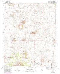
1971 Map of Cerro Hueco
USGS Topo · Published 1985About this map
Cerro Hueco and Cerro Montoso dominate this high-desert landscape in Apache County, captured during a 1971 field check. This region is defined by its water management for livestock, with a network of isolated tanks and wells such as the Santa Fe Well, Blood Tank, and Dead Horse Tank scattered across the terrain. These features, along with a solitary Corral and several Water Tanks, suggest a ranching economy reliant on seasonal drainages like Wildcat Creek and Mallory Creek.
Find a feature on this map
19 named features on this map. Tap any name to fly to it.
Don’t see what you’re looking for? This feature index may not catch every label — zoom into the map to look around manually.
Map Details
Editions of this 1971 Cerro Hueco Map
3 editions found
Other maps of this area

1886 · St Johns
USGS Topo · 1:250,000

1892 · St Johns
USGS Topo · 1:250,000

1954 · Saint Johns
USGS Topo · 1:250,000

1957 · Saint Johns
USGS Topo · 1:250,000

1958 · Saint Johns
USGS Topo · 1:250,000

1962 · Saint Johns
USGS Topo · 1:250,000

1968 · Boundary Butte
USGS Topo · 1:24,000

1968 · Springerville NW
USGS Topo · 1:24,000

1969 · Whiting Knoll
USGS Topo · 1:24,000
1971 · Cerro Hueco
USGS Topo · 1:24,000