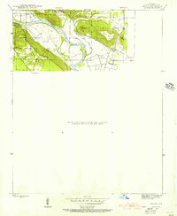
1942 Map of Salado
USGS Topo · Published 1956About this map
The White River carves a winding path through the heart of Independence County, defining the agricultural and topographic character of the region in the early 1940s. Along its northern banks, the terrain is dominated by the ridges of Pine Mtn and Qualls Mtn, while the southern floodplain shows a complex network of backwaters and oxbows, including the distinctive Old River loop. This landscape of river bottoms and elevated ridges supported small communities and named landmarks like Montgomery Sprs and the pass known as Mountain Gap. Small creeks like Rutherford Creek feed the main river, illustrating the drainage patterns that dictated early road placement and property lines across the historic townships of Salado, Moorefield, and Magness.
Find a feature on this map
18 named features on this map. Tap any name to fly to it.
Don’t see what you’re looking for? This feature index may not catch every label — zoom into the map to look around manually.
Map Details
Editions of this 1942 Salado Map
2 editions found
Other maps of this area

1890 · Batesville
USGS Topo · 1:125,000

1891 · Batesville
USGS Topo · 1:125,000

1932 · Strawberry
USGS Topo · 1:62,500

1935 · Strawberry
USGS Topo · 1:62,500

1935 · Newport
USGS Topo · 1:62,500

1941 · Strawberry
USGS Topo · 1:62,500

1942 · Jamestown
USGS Topo · 1:31,680

1942 · Salado
USGS Topo · 1:31,680

1942 · Batesville
USGS Topo · 1:31,680

1943 · Sulphur Rock
USGS Topo · 1:31,680