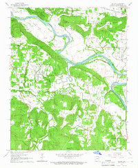
1965 Map of Salado
USGS Topo · Published 1966About this map
White River oxbows and islands dominate this 1960s landscape, where the Missouri Pacific railroad cuts through the northern bottoms. The community of Salado sits centrally among several prominent elevations like Egner Hill and Bill Hill, while smaller settlements such as Rosie and Southside serve as local hubs. The map reveals a deeply etched drainage system where Salado Creek and Caney Creek wind toward the larger river valley, shaping the placement of early homesteads and cemeteries.
Find a feature on this map
50 named features on this map. Tap any name to fly to it.
Don’t see what you’re looking for? This feature index may not catch every label — zoom into the map to look around manually.
Map Details
Editions of this 1965 Salado Map
2 editions found
Other maps of this area

1890 · Batesville
USGS Topo · 1:125,000

1891 · Batesville
USGS Topo · 1:125,000

1932 · Strawberry
USGS Topo · 1:62,500

1935 · Strawberry
USGS Topo · 1:62,500

1935 · Newport
USGS Topo · 1:62,500

1941 · Strawberry
USGS Topo · 1:62,500

1942 · Jamestown
USGS Topo · 1:31,680

1942 · Salado
USGS Topo · 1:31,680

1942 · Batesville
USGS Topo · 1:31,680

1943 · Sulphur Rock
USGS Topo · 1:31,680