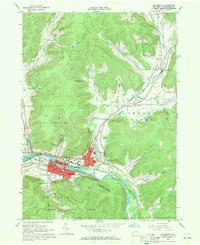
1961 Map of Salamanca
USGS Topo · Published 1971About this map
The Allegheny River valley forms the industrial and cultural heart of this 1961 landscape, dominated by the Salamanca city center and the surrounding Allegheny Indian Reservation. A complex rail network including the Baltimore and Ohio, Erie-Lackawanna, and Pennsylvania railroads converges here, reflecting the city’s role as a transportation hub. Beyond the urban grid, the map details numerous smaller communities such as Kill Buck, Peth, and Great Valley, alongside rural landmarks like the Whig St Ch and Little Rock City. To the south, the northern edge of Allegany State Park rises sharply from the riverbank. This edition records a moment when local infrastructure was densely packed with neighborhood institutions, from School No 1 and Jefferson St Sch to several cemeteries and the Salamanca Airport, providing an intricate look at the mid-century layout of Cattaraugus County.
Find a feature on this map
63 named features on this map. Tap any name to fly to it.
Don’t see what you’re looking for? This feature index may not catch every label — zoom into the map to look around manually.
Map Details
Editions of this 1961 Salamanca Map
Other maps of this area

1900 · Salamanca
USGS Topo · 1:62,500

1922 · Randolph
USGS Topo · 1:62,500

1923 · Randolph
USGS Topo · 1:62,500

1923 · Cattaraugus
USGS Topo · 1:62,500

1924 · Ellicottville
USGS Topo · 1:62,500

1938 · Cattaraugus
USGS Topo · 1:62,500

1938 · Salamanca
USGS Topo · 1:62,500

1941 · Cattaraugus
USGS Topo · 1:62,500

1941 · Ellicottville
USGS Topo · 1:62,500

1943 · Randolph
USGS Topo · 1:62,500