1996 Map of Salem
USGS Topo · Published 2000About this map
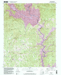
Lake Jocassee and Lake Keowee dominate this landscape on the border of Oconee and Pickens Counties, reflecting a mid-20th-century transformation of the upper Piedmont. While the topography was compiled in the 1950s, this later edition shows the established waters of the reservoir system and protected lands like Devils Fork State Park and Keowee Toxaway State Park. The town of Salem serves as a central point of settlement, surrounded by rural landmarks including the Salem Davidian Ch and McKinney Chapel. The map documents the convergence of the Toxaway River, Whitewater River, and Thompson River, whose original paths are now part of the lake system. High points such as McKinney Mtn and Smeltzer Mtn rise above the drainage basins, with a Lookout Tower positioned for forest surveillance within the Sumter National Forest.
Find a feature on this map
52 named features on this map. Tap any name to fly to it.
Don’t see what you’re looking for? This feature index may not catch every label — zoom into the map to look around manually.
Map Details
Editions of this 1996 Salem Map
This is the sole edition of this map. No revisions or reprints were ever made.
Other maps of this area

1886 · Walhalla
USGS Topo · 1:125,000

1888 · Pickens
USGS Topo · 1:125,000

1891 · Cowee
USGS Topo · 1:125,000

1892 · Walhalla
USGS Topo · 1:125,000

1894 · Pickens
USGS Topo · 1:125,000

1896 · Walhalla
USGS Topo · 1:125,000

1897 · Cowee
USGS Topo · 1:125,000

1905 · Pisgah
USGS Topo · 1:125,000

1906 · Pisgah
USGS Topo · 1:125,000

1907 · Cowee
USGS Topo · 1:125,000