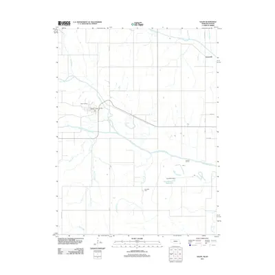
2011 Map of Salem
USGS Topo · Published 2011About this map
The confluence of the North Fork Big Nemaha River and South Fork Big Nemaha River dominates this Richardson County landscape, where the town of Salem serves as the primary hub. This 2011 survey illustrates a region defined by agricultural water management and energy extraction, featuring the Falls City Oil Field and significant infrastructure such as the Towle-Martin Dam and Campbell Dam. The settlement of Straussville appears in the northeast, connected by rural routes like Straussville Rd. Local history is anchored at the Salem Post Office and Maple Cemetery, while a complex network of tributaries, including Contrary Creek and Wildcat Creek, drain the surrounding terrain. The convergence of these watercourses into the main Big Nemaha River channel highlights the area's importance as a drainage basin for southeastern Nebraska.
Find a feature on this map
27 named features on this map. Tap any name to fly to it.
Don’t see what you’re looking for? This feature index may not catch every label — zoom into the map to look around manually.
Map Details
Editions of this 2011 Salem Map
This is the sole edition of this map. No revisions or reprints were ever made.
Other maps of this area

1888 · Hiawatha
USGS Topo · 1:125,000

1894 · Hiawatha
USGS Topo · 1:125,000

1915 · Falls City
USGS Topo · 1:62,500

1916 · Humboldt
USGS Topo · 1:62,500

1950 · Kansas City
USGS Topo · 1:250,000

1954 · Kansas City
USGS Topo · 1:250,000

1955 · Nebraska City
USGS Topo · 1:250,000

1956 · Kansas City
USGS Topo · 1:250,000

1957 · Nebraska City
USGS Topo · 1:250,000

1958 · Nebraska City
USGS Topo · 1:250,000