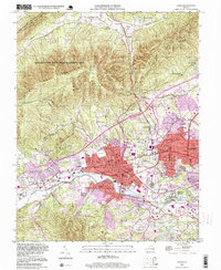
1994 Map of Salem
USGS Topo · Published 1999About this map
The Roanoke River valley defines the landscape of this 1990s survey, where the urban expansion of Salem meets the steep rising terrain of Lewis Mountain and Brush Mountain. The city's core is centered around the historic campus of Roanoke College and the Andrew Lewis Jr High Sch, showing a densely developed grid that transitions into industrial sites along the Norfolk and Western RR. To the north, the Appalachian National Scenic Trail traverses the ridges of the Havens State Wildlife Management Area, providing a sharp contrast to the suburban growth in Sunset Village and Beverly Heights. Notable regional infrastructure is well-represented, from the sprawling Veterans Administration Hospital and Sherwood Burial Park to the Lakeside Amusement Park and the varied crossings of the Lynchburg Turnpike.
Find a feature on this map
64 named features on this map. Tap any name to fly to it.
Don’t see what you’re looking for? This feature index may not catch every label — zoom into the map to look around manually.
Map Details
Editions of this 1994 Salem Map
This is the sole edition of this map. No revisions or reprints were ever made.
Other maps of this area

1890 · Roanoke
USGS Topo · 1:125,000

1890 · Christiansburg
USGS Topo · 1:125,000

1891 · Roanoke
USGS Topo · 1:125,000

1929 · Roanoke
USGS Topo · 1:48,000

1929 · Salem
USGS Topo · 1:48,000

1932 · Salem
USGS Topo · 1:62,500

1933 · Roanoke
USGS Topo · 1:62,500

1947 · Roanoke
USGS Topo · 1:250,000

1950 · Elliston
USGS Topo · 1:62,500

1951 · Boones Mill
USGS Topo · 1:62,500