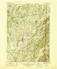
1946 Map of Salem
USGS Topo · Published 1946About this map
Salem serves as the central hub of this 1946 landscape, where the Delaware and Hudson railroad and White Creek intersect. The terrain is defined by the significant elevations of Hebron Mtn to the north and the ridges of Wheeler Hill and Flatback Ridge to the east, which frame the fertile valleys where agriculture and small settlements took root. Genealogists will find a wealth of data in the numerous burial grounds, including the Evergreen Cem and Catholic Cem south of the village, as well as the more remote Parish Cem and Cleveland Cem near the northern boundary. The southern portion of the sheet is dominated by the winding path of the Batten Kill, a major waterway that passes through Rexleigh near the Greenwich Junc rail junction. This survey captures a moment in Washington County history before post-war development altered the rural character of these valleys and hillsides.
Find a feature on this map
36 named features on this map. Tap any name to fly to it.
Don’t see what you’re looking for? This feature index may not catch every label — zoom into the map to look around manually.
Map Details
Editions of this 1946 Salem Map
This is the sole edition of this map. No revisions or reprints were ever made.
Other maps of this area

1893 · Fort Ann
USGS Topo · 1:62,500

1894 · Pawlet
USGS Topo · 1:62,500

1894 · Equinox
USGS Topo · 1:62,500

1895 · Cambridge
USGS Topo · 1:62,500

1895 · Fort Ann
USGS Topo · 1:62,500

1896 · Equinox
USGS Topo · 1:62,500

1897 · Pawlet
USGS Topo · 1:62,500

1898 · Cambridge
USGS Topo · 1:62,500

1898 · Fort Ann
USGS Topo · 1:62,500

1900 · Equinox
USGS Topo · 1:62,500