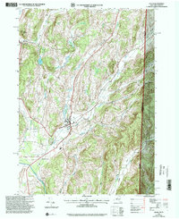
1995 Map of Salem
USGS Topo · Published 2000About this map
Salem serves as the central hub for this late-20th-century survey of the borderlands between Washington County and Bennington County. The landscape is defined by the winding course of the Batten Kill and numerous drainage systems like White Creek and Camden Creek. In addition to the larger village, smaller locales such as Rexleigh and West Hebron are documented, along with the industrial and transit connection at Greenwich Junc. The map provides excellent genealogical detail, marking several burial sites including Evergreen Cem, Catholic Cem, and the more isolated Cleveland Cem.
Find a feature on this map
34 named features on this map. Tap any name to fly to it.
Don’t see what you’re looking for? This feature index may not catch every label — zoom into the map to look around manually.
Map Details
Editions of this 1995 Salem Map
This is the sole edition of this map. No revisions or reprints were ever made.
Other maps of this area

1893 · Fort Ann
USGS Topo · 1:62,500

1894 · Pawlet
USGS Topo · 1:62,500

1894 · Equinox
USGS Topo · 1:62,500

1895 · Cambridge
USGS Topo · 1:62,500

1895 · Fort Ann
USGS Topo · 1:62,500

1896 · Equinox
USGS Topo · 1:62,500

1897 · Pawlet
USGS Topo · 1:62,500

1898 · Cambridge
USGS Topo · 1:62,500

1898 · Fort Ann
USGS Topo · 1:62,500

1900 · Equinox
USGS Topo · 1:62,500