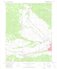
1983 Map of Salida West
USGS Topo · Published 1983About this map
The Arkansas River corridor in the early 1980s reveals a complex landscape of irrigation and industry west of the Chaffee County seat. The town of Salida and the nearby community of Smeltertown are central to the region's development, supported by the Denver and Rio Grande Western railroad tracks. This map documents an extensive network of gravity-fed water systems, including the Kraft Ditch, Salida Ditch, and Park Ditch, which transform the arid plains of Sand Park and Adobe Park into productive land. Local history and genealogy interests are represented by the Fairview Cem, Longfellow Sch, and the Shavano State Fish Hatchery. The transition from the flat agricultural expanses of Missouri Park to the protected slopes of the San Isabel National Forest illustrates the intersection of human engineering and the natural Rocky Mountain environment.
Find a feature on this map
43 named features on this map. Tap any name to fly to it.
Don’t see what you’re looking for? This feature index may not catch every label — zoom into the map to look around manually.
Map Details
Editions of this 1983 Salida West Map
3 editions found
Other maps of this area

1954 · Pueblo
USGS Topo · 1:250,000

1956 · Cameron Mountain
USGS Topo · 1:62,500

1956 · Poncha Springs
USGS Topo · 1:62,500

1956 · Montrose
USGS Topo · 1:250,000

1957 · Pueblo
USGS Topo · 1:250,000

1958 · Pueblo
USGS Topo · 1:250,000

1959 · Montrose
USGS Topo · 1:250,000

1959 · Bonanza
USGS Topo · 1:62,500

1959 · Howard
USGS Topo · 1:62,500

1960 · Montrose
USGS Topo · 1:250,000