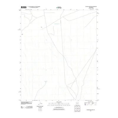
2010 Map of Salinas Peak NW
USGS Topo · Published 2010About this map
Chavez Ranch and Jac Ranch anchor this sparse New Mexico landscape, illustrating the remote ranching operations characteristic of Socorro County in the early 21st century. The terrain is defined by a complex network of ephemeral drainage patterns flowing south and west across the high desert. Essential water management features, including Anderson Tank and Broke Tank, are critical landmarks in this arid environment, supporting local livestock and wildlife. Transportation in the area is primarily served by the WSMR P Route 5, which traverses the northern portion of the quadrangle. This survey provides a clear view of the relationship between minimal human settlement and the natural topography of the Tularosa Basin region during this era.
Find a feature on this map
5 named features on this map. Tap any name to fly to it.
Don’t see what you’re looking for? This feature index may not catch every label — zoom into the map to look around manually.
Map Details
Editions of this 2010 Salinas Peak NW Map
This is the sole edition of this map. No revisions or reprints were ever made.
Other maps of this area

1916 · Salinas Peak
USGS Topo · 1:125,000

1948 · Granjean Well
USGS Topo · 1:62,500

1948 · Val Verde
USGS Topo · 1:62,500

1948 · Malpais Well
USGS Topo · 1:62,500

1948 · Salinas Peak
USGS Topo · 1:62,500

1954 · Tularosa
USGS Topo · 1:250,000

1958 · Tularosa
USGS Topo · 1:250,000

1981 · Big Gyp Mountain
USGS Topo · 1:24,000

1981 · Fairview Mountain
USGS Topo · 1:24,000
1981 · Salinas Peak
USGS Topo · 1:24,000