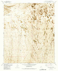
1981 Map of Salinas Peak NW
USGS Topo · Published 1982About this map
White Sands Missile Range dominates this arid landscape at the border of Socorro and Sierra counties. The terrain is defined by its scarce water resources and ancient volcanic activity, with a notable field of Lava visible in the northwest corner. This area serves as a restricted military zone, yet the presence of the Marcial Site and a designated School Site suggests a layer of human activity or historical occupancy within the high-desert environment.
Find a feature on this map
16 named features on this map. Tap any name to fly to it.
Don’t see what you’re looking for? This feature index may not catch every label — zoom into the map to look around manually.
Map Details
Editions of this 1981 Salinas Peak NW Map
This is the sole edition of this map. No revisions or reprints were ever made.
Other maps of this area

1916 · Salinas Peak
USGS Topo · 1:125,000

1948 · Granjean Well
USGS Topo · 1:62,500

1948 · Val Verde
USGS Topo · 1:62,500

1948 · Malpais Well
USGS Topo · 1:62,500

1948 · Salinas Peak
USGS Topo · 1:62,500

1954 · Tularosa
USGS Topo · 1:250,000

1958 · Tularosa
USGS Topo · 1:250,000

1981 · Big Gyp Mountain
USGS Topo · 1:24,000

1981 · Fairview Mountain
USGS Topo · 1:24,000
1981 · Salinas Peak
USGS Topo · 1:24,000