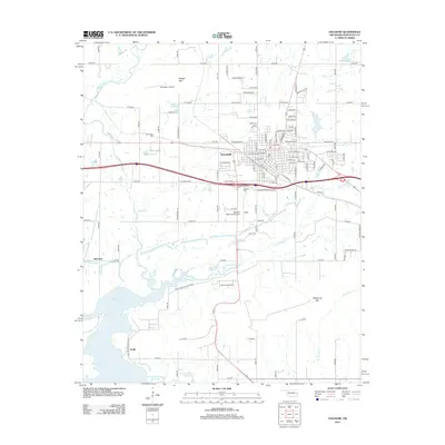
2012 Map of Sallisaw
USGS Topo · Published 2012About this map
Sallisaw serves as the focal point of this Eastern Oklahoma landscape, situated just north of the expansive Robert S Kerr Reservoir. The map illustrates the transition from the city's residential and municipal grid—including the Sallisaw Municipal Airport and Sallisaw Cem—to the lower-lying bottoms and drainages of the Little Sallisaw Cr and Shiloh Br. To the north and south, the terrain rises toward Badger Mtn and Wildhorse Mtn, framing the Arkansas River valley's northern reaches. Genealogists and local historians can locate smaller settlements such as Harrison and Sadie near the reservoir's edge, along with the Buffington Cem located northwest of the main town. The network of section line roads like N 4610 Rd and E 1100 Rd provides a clear structure for tracing old homesteads and the evolution of rural land use in Sequoyah Co.
Find a feature on this map
103 named features on this map. Tap any name to fly to it.
Don’t see what you’re looking for? This feature index may not catch every label — zoom into the map to look around manually.
Map Details
Editions of this 2012 Sallisaw Map
This is the sole edition of this map. No revisions or reprints were ever made.
Other maps of this area

1898 · Tahlequah
USGS Topo · 1:125,000

1900 · Sallisaw
USGS Topo · 1:125,000

1901 · Tahlequah
USGS Topo · 1:125,000

1905 · Tahlequah
USGS Topo · 1:125,000

1911 · Sallisaw
USGS Topo · 1:125,000

1946 · Fort Smith
USGS Topo · 1:250,000

1965 · Fort Smith
USGS Topo · 1:250,000

1966 · Gans
USGS Topo · 1:24,000

1966 · Muldrow SW
USGS Topo · 1:24,000

1967 · Fort Smith
USGS Topo · 1:250,000