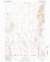
1983 Map of Sally Mountain
USGS Topo · Published 1983About this map
The Hill Air Force Range dominates the basin between two prominent desert ranges in this 1983 study of northwestern Utah. This specialized military landscape is characterized by its infrastructure for aviation and logistics, featuring multiple Heliports and a secondary Heliport alongside an extensive Aqueduct system that cuts across the arid floor. The terrain transitions abruptly from these installations into the steep ridges of the Lakeside Mountains and the Sally Mountain Mountains, where a Radio Tower marks a high point above Wrathall Pass. Numerous Gravel Pit operations are scattered across the alluvial fans at the base of the mountains, indicating active material extraction. This map captures the intersection of industrial mining and military defense operations in a remote section of Box Elder and Toole Counties during the early 1980s.
Find a feature on this map
15 named features on this map. Tap any name to fly to it.
Don’t see what you’re looking for? This feature index may not catch every label — zoom into the map to look around manually.
Map Details
Editions of this 1983 Sally Mountain Map
This is the sole edition of this map. No revisions or reprints were ever made.
Other maps of this area

1885 · Tooele Valley
USGS Topo · 1:250,000

1953 · Tooele
USGS Topo · 1:250,000

1954 · Brigham City
USGS Topo · 1:250,000

1955 · Tooele
USGS Topo · 1:250,000

1958 · Brigham City
USGS Topo · 1:250,000

1962 · Brigham City
USGS Topo · 1:250,000

1968 · Deardens Knoll
USGS Topo · 1:24,000

1968 · Craner Peak
USGS Topo · 1:24,000

1969 · Hogup Ridge South
USGS Topo · 1:24,000

1969 · Strongs Knob
USGS Topo · 1:24,000