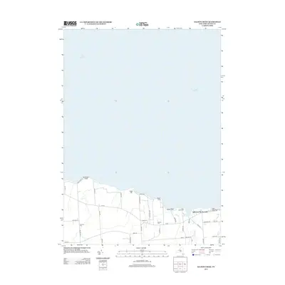
2013 Map of Salmon Creek
USGS Topo · Published 2013About this map
The shoreline of Lake Ontario defines the northern edge of this coastal landscape in Wayne County, where the intricate geography of Maxwell Bay and Salmon Cr meets the water. Settlement is clustered around the lakefront, most notably at Idlewood On The Lake, reflecting the region’s long-standing draw as a seasonal and recreational destination. The interior landscape is marked by agricultural activity, specifically the Sodus Fruit Farm, and a network of roads that follow the early property lines of the town of Sodus.
Find a feature on this map
42 named features on this map. Tap any name to fly to it.
Don’t see what you’re looking for? This feature index may not catch every label — zoom into the map to look around manually.
Map Details
Editions of this 2013 Salmon Creek Map
This is the sole edition of this map. No revisions or reprints were ever made.
Other maps of this area

1899 · Palmyra
USGS Topo · 1:62,500

1902 · Sodus Bay
USGS Topo · 1:62,500

1902 · Pultneyville
USGS Topo · 1:62,500

1902 · Clyde
USGS Topo · 1:62,500

1902 · Palmyra
USGS Topo · 1:62,500

1942 · Pultneyville
USGS Topo · 1:31,680

1943 · Williamson
USGS Topo · 1:31,680

1943 · Sodus Point
USGS Topo · 1:31,680

1943 · Sodus
USGS Topo · 1:31,680
1943 · Rose
USGS Topo · 1:31,680