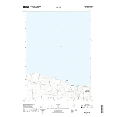
2019 Map of Salmon Creek
USGS Topo · Published 2019About this map
The south shore of Lake Ontario dominates this portion of Wayne County, where the village of Sodus Point sits near the mouth of Salmon Cr. The landscape is characterized by a series of prominent coastal features, including Bootleggers Point, Boller Point, and the elevation of Negro Hill. Agricultural land use is evident through landmarks like the Sodus Fruit Farm, which occupies a significant portion of the shoreline terrain. Further inland, the map preserves the locations of local burial grounds such as Centenary Cem, Swales Cem, and Bushnell Cem. These sites, along with a network of rural roads like Co RD 101 and Bear Swamp Rd, reflect the long-standing community structure of this lakeside region. The topography includes distinct glacial features like Sprong Bluff overlooking Maxwell Bay, where Mink Creek meets the lake waters.
Find a feature on this map
37 named features on this map. Tap any name to fly to it.
Don’t see what you’re looking for? This feature index may not catch every label — zoom into the map to look around manually.
Map Details
Editions of this 2019 Salmon Creek Map
This is the sole edition of this map. No revisions or reprints were ever made.
Other maps of this area

1899 · Palmyra
USGS Topo · 1:62,500

1902 · Sodus Bay
USGS Topo · 1:62,500

1902 · Pultneyville
USGS Topo · 1:62,500

1902 · Clyde
USGS Topo · 1:62,500

1902 · Palmyra
USGS Topo · 1:62,500

1942 · Pultneyville
USGS Topo · 1:31,680

1943 · Williamson
USGS Topo · 1:31,680

1943 · Sodus Point
USGS Topo · 1:31,680

1943 · Sodus
USGS Topo · 1:31,680
1943 · Rose
USGS Topo · 1:31,680