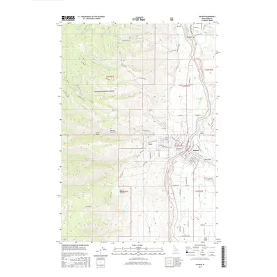
2017 Map of Salmon
USGS Topo · Published 2017About this map
Salmon serves as the focal point of this Idaho survey, situated where the Salmon River and Lemhi River converge. The landscape is defined by the high elevations of the Salmon River Mountains and the Salmon National Forest, with Morning Glory Peak standing as a prominent local landmark. The survey documents the integration of water management and transportation in the Lemhi Valley, tracing the Big Flat Ditch alongside the historic route of the Lewis and Clark Trl. On the eastern edge of the valley, the Lemhi County Airport and the City Cem mark the outskirts of the town. This area exhibits a transition from the structured street grid of Salmon—featuring roads like Roosevelt Ave and Leadore Ave—to the expansive terrain of Big Flat and Pollard Canyon, illustrating the relationship between the river-bottom settlements and the surrounding mountain wilderness.
Find a feature on this map
91 named features on this map. Tap any name to fly to it.
Don’t see what you’re looking for? This feature index may not catch every label — zoom into the map to look around manually.
Map Details
Editions of this 2017 Salmon Map
This is the sole edition of this map. No revisions or reprints were ever made.
Other maps of this area

1950 · Salmon
USGS Topo · 1:62,500

1950 · Leesburg
USGS Topo · 1:62,500

1951 · Leesburg
USGS Topo · 1:62,500

1951 · Salmon
USGS Topo · 1:62,500

1955 · Dillon
USGS Topo · 1:250,000

1956 · Elk City
USGS Topo · 1:250,000

1957 · Dillon
USGS Topo · 1:250,000

1958 · Dillon
USGS Topo · 1:250,000

1960 · Elk City
USGS Topo · 1:250,000

1960 · Ulysses Mtn
USGS Topo · 1:62,500